
326 - 350 of 75772 results
| Item | Title | Type | Unique ID | Kinsman | Kinsman Kind | Family | Ethnicity | Mention Type | Category | Date | YMD | Warnings | Variants | Rec No | Manuscript ID | Place Event | Place Vital | Source 1 | Source ID 1 | Lat / Lon | Alias | Link 1 | |
|---|---|---|---|---|---|---|---|---|---|---|---|---|---|---|---|---|---|---|---|---|---|---|---|
| 25215 | A Mahican, Abenaki or Sokoki in La Salle's party. |
|
|
|
|
|
|
|
|
|
| ||||||||||||
| 25409 | A Mahican, Abenaki or Sokoki in La Salle's party. |
|
|
|
|
|
|
|
|
|
|
| |||||||||||
| 36603 | A Mahican, Abenaki or Sokoki in La Salle's party. |
|
|
|
|
|
|
|
|
|
| ||||||||||||
| 37999 | A Mahican, Abenaki or Sokoki in La Salle's party. |
|
|
|
|
|
|
|
|
|
| ||||||||||||
| 39301 | A Mahican, Abenaki or Sokoki in La Salle's party. |
|
|
|
|
|
|
|
|
|
| ||||||||||||
| 43606 | A Mahican, Abenaki or Sokoki in La Salle's party. |
|
|
|
|
|
|
|
|
|
| ||||||||||||
| 48626 | A Mahican, Abenaki or Sokoki in La Salle's party. |
|
|
|
|
|
|
|
|
|
| ||||||||||||
| 51047 | A Mahican, Abenaki or Sokoki in La Salle's party. |
|
|
|
|
|
|
|
|
|
| ||||||||||||
| 51302 | A Mahican, Abenaki or Sokoki in La Salle's party. |
|
|
|
|
|
|
|
|
|
| ||||||||||||
| 55099 | A Mahican, Abenaki or Sokoki in La Salle's party. |
|
|
|
|
|
|
|
|
|
| ||||||||||||
| 56719 | A Mahican, Abenaki or Sokoki in La Salle's party. |
|
|
|
|
|
|
|
|
|
| ||||||||||||
| 135581 | A Mahican, Abenaki or Sokoki in La Salle's party. |
|
|
|
|
|
|
| |||||||||||||||
| 11287 | A Mahican. |
|
|
|
|
|
|
|
|
|
|
| |||||||||||
| 600044 | A Map of the Locality of Lovewell's Fight. |
|
|
| 
Description: The map shows the area where New Hampshire Colonel John Lovewell and his company were attacked and overcome by Indians on May 9, 1725 during Dummer's war. It shows (#1) the location of the Pigwacket village in Fryeburg, ME on the east side of the Saco River. | ||||||||||||||||||
| 400285 | A Mapp of New England. Courtesy of the the Library of Congress. |
| 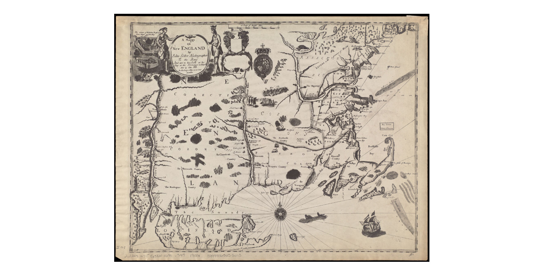
Description: Published in 1676 by John Seller, this map was based on a 1665 survey to support the colonial boundaries described in Massachusetts 1628 royal charter. A stylized Indian village appears in the upper left. View this map in detail here:https://collections.leventhalmap.org/search/commonwealth:3f462s90h | ||||||||||||||||||||
| 56677 | A meadow named for him? |
|
|
|
|
|
|
|
|
|
|
| |||||||||||
| 17261 | A Micmac chief. Hopson sent Holdernesse a copy of the treaty he signed. |
|
|
|
|
|
|
|
|
|
|
| |||||||||||
| 47181 | A Micmac. |
|
|
|
|
|
|
|
|
| |||||||||||||
| 51559 | A Micmac. |
|
|
|
|
|
|
|
|
| |||||||||||||
| 34126 | A Micmac. |
|
|
|
|
|
|
|
|
| |||||||||||||
| 41906 | A Micmac. |
|
|
|
|
|
|
|
|
|
|
| |||||||||||
| 102955 | A Micmac. |
|
|
|
|
|
| ||||||||||||||||
| 35851 | A miserable character with a twitching face. |
|
|
|
|
|
|
|
| ||||||||||||||
| 14154 | A Montagnais war leader, sent his son to France. |
|
|
|
|
|
|
|
|
|
| ||||||||||||
| 23507 | A mulato arraigned for wife beating. |
|
|
|
|
|
|
|
|
|
|


Save these search results as a PDF file